 |

|
|

|
Updated Street and POI DataThis excerpt from the first edition of MP2Kmag's Guide to What's New in MapPoint 2004 highlights the new data in the North American version
A Better �Cut� One of the MapPoint product�s interesting features is that it combines the street and other cartographic layers of a couple of the premiere digital street data providers, using the respective provider in the areas where each is most accurate. Navtech, located here in Chicago, constructed their database using a nationwide fleet of vans equipped with GPS units making their street data the most precise and appropriate for vehicle routing applications. To make the requisite number of miles driven manageable, Navtech concentrated on major urban areas and highways. Their coverage of small towns and rural areas such as township and county roads is somewhat lacking and inferior to GDT�s coverage which aims to have 100% coverage of the U.S. Each release, the MapPoint teams make a �cut�, merging the two data sources together using GIS tools including proprietary algorithms. In my examination and observation, MapPoint 2004 appears to be much better cut than MapPoint 2002. Below are some examples where MapPoint 2002 had some problems in the coverage which are fixed in MapPoint 2004.  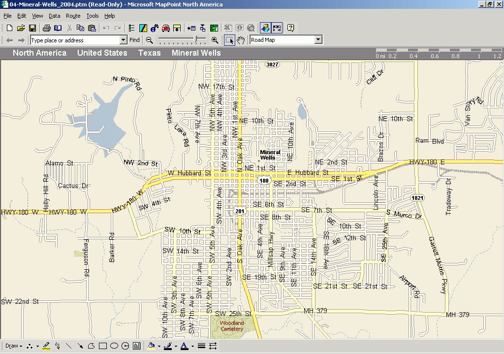 In the maps above you can see that streets for Mineral Wells, TX are almost completely missing from the MapPoint 2002 version. The gray area and dotted line show areas for which Microsoft used the Navtech streets. Navtech's detailed coverage apparently does not (or did not � this was a few years ago already) extend out from the Dallas-Fort Worth metropolitan region as far as Mineral Wells. The next maps are an overview which shows more of what is happening. In the MapPoint 2002 map, you can see the gray area around Fort Worth roughly following the county boundaries. In particular you can see how the gray area and dotted line jut out toward the west to include Mineral Wells, as you can see in the maps above, this was not a good idea as Navtech coverage of Mineral Wells was poor. The MapPoint 2004 map shows the gray area delineated with much more precision, the dotted line does not merely follow the county lines. This shows a much greater level of care taken in assembling the maps. [See Fort Worth And Surroundings] Puerto Rico Computer users in Puerto Rico users can now enjoy many of MapPoint's features as the territory was added to MapPoint with the 2004 release and it is a welcome addition for many North American users who do business or travel in Puerto Rico. Puerto Rico geocoding in general presents some extra challenges compared to geocoding in the 50 U.S. states so I decided to give it a whirl. Working interactively MapPoint does not understand Puerto Rican addresses placed in the Find Box or Dialog as it does not recognize �PR� or Puerto Rico as a state. When importing a list, however, it is able to find some streets which is interesting (you can download a test file from MP2Kmag here) but it is not capable of matching to address ranges. It does fine as MapPoint does worldwide in finding place locations (sample file here). Puerto Rico might be considered on par with the Mexico data which allows routing but no geocoding functionality, but the data for Puerto Rico is much more detailed. Also, I found it interesting to discover that while address-level geocoding is not explicitly supported with Puerto Rico, it still manages to find streets. I do not know whether it is in fact GDT providing the street data for Puerto Rico, but I do know that GDT provides higher-quality geocoding services for the island.
featured resources
Points of Interest The number of business or points of interest have jumped dramatically in MapPoint 2004 and now number 1.4 million, up from 800,000 in MapPoint 2002. InfoUSA has been replaced as a provider of business listings by Acxiom, and other places are sourced from Navtech, GDT, and Woodall's � the "Rving" and camping information company. While the number of Place categories has increased to 33 from 32, some place categories have disappeared. Gone are post offices and highway exit services while in the plus column, MapPoint now has categories for grocery stores and ski areas, and banks and ATM's are now separated into two categories. Using the downtown post office location in Madison, Wis. As a reference point, Find Nearby Places in MapPoint 2002 returns 181 locations in 24 categories (12 restaurant and 12 place) while MapPoint 2004 lists 239 places in 18 categories (4 restaurant and 14 place). One striking difference you see is that not nearly as many restaurants are categorized. While 69 out of 103 restaurants (67%) are not categorized with MapPoint 2002, 92% of restaurants are not categorized in MapPoint 2004. I decided this warranted further investigation and I did not find any other example with as large a decrease in the percentage of restaurants categorized, although in all instances there was some decrease. Here's what it looks like for Manhattan: While the results are much better for both versions (a lot fewer restaurants in All Other), the decrease in categorization still appears with the percent in the "Other" category going up from 36% to 41%. In other tests, for Des Moines, IA the percentage of uncategorized restaurants goes from 67% to 80% using a 50 mile radius. For St. Louis it goes from 56% to 57%. Despite attempts to explain the many uses and applications of MapPoint for business, my fianc�e will always first think of MapPoint as a restaurant-finding tool (i.e. show me all the Seafood restaurants within 1, 3, and 5 miles of the hotel). For her and users like her, the decrease in categorization is a step backward. You have just read a small fraction of what's available in the MP2Kmag Guide to What's New in MapPoint 2004. To purchase the full guide, click here. 
Author: Eric Frost Email: website(AT)mp2kmag.com URL: http://www.mp2kmag.com Eric is Editor and Publisher of MP2K Magazine and is a part-time student in University of Chicago's evening MBA program. Eric recently finished the MP2Kmag Guide What's New in MapPoint 2004.
|
|
|||||||||||||||||||||||||||||||||||||||||||||||||||||||||||||||||||
|
|
|||||||||||||||||||||||||||||||||||||||||||||||||||||||||||||||||||||


